Bachelor Civil Engineering and Geodesy - Geodesy specialisation

Civil engineering and geodesy – a fully-fledged geodesy degree programme

What is a geodesist?

As a geodesist, you measure, analyse, and visualise our world and how it is changing. To do this, you use state-of-the-art digital measuring systems that observe the world with the highest precision, starting from global scales down to the smallest sections, often only a few mm in size. The use of remote sensing systems, but also drones and laser scanners and sub-millimetre accurate special sensors are part of your measurement competence. You visualise and analyse the results with the help of geoinformation systems and Building Information Modelling methods, e.g. as 3D building or city models. You change and shape the world with land management methods (e.g. urban development planning and its implementation taking into account economic, ecological and social aspects). You are therefore an interdisciplinary engineer. From “Technology & Industry” and “Climate & Environment” to “Land & Soil” and “Apps & Mobility” – the profession is just as complex as the topics you deal with.

Why study geodesy at TU Darmstadt?

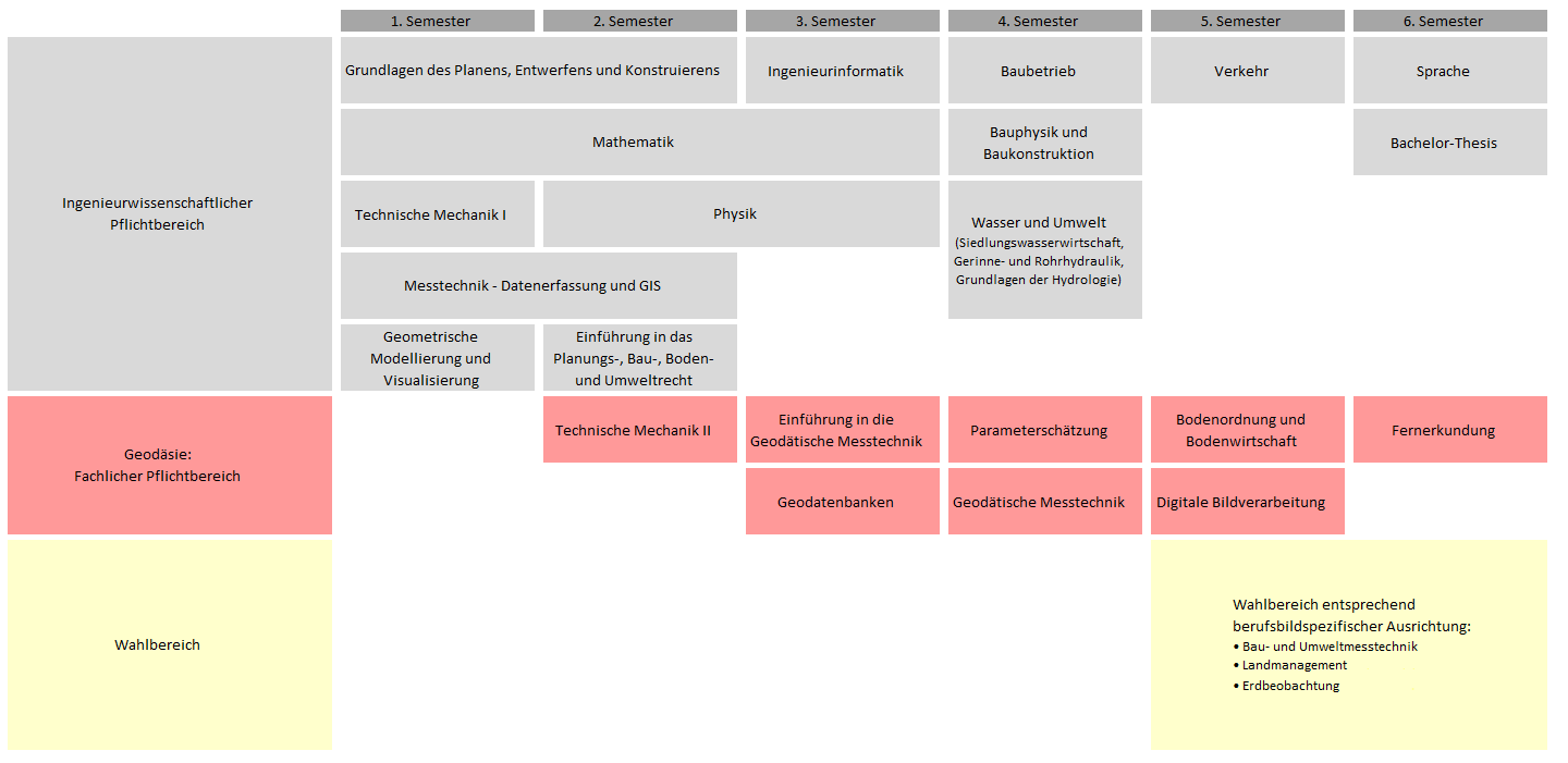
If you study the six-semester B.Sc. degree programme in Civil Engineering and Geodesy offered here, with the specialisation Geodesy , you will be taught all the basic skills needed to work successfully in the professional field described above. In addition, our degree programme gives you the opportunity to set your own subject specialisations in combination with other civil engineering specialisations or the degree programmes in environmental engineering or industrial engineering. In any case, you will study directly in an interdisciplinary environment, as you will regularly meet students from other degree programmes in the individual modules of the geodesy specialisation.

The six-semester Bachelor of Science Civil Engineering with a specialisation in Geodesy comprises 180 credit points (CP – Credit Points). It is divided into the compulsory engineering area (Study programme regulations ), in which the basic scientific and technical knowledge is taught, and the specialised studies (this includes a compulsory and an elective area), in which the students acquire specialised content for a subsequent (consecutive) Master's degree programme or a first professional activity on the basis of recommended career profiles. At TU Darmstadt, however, the Master of Science is considered the standard degree and is therefore recommended.

The study programme Geodesy is divided into the following main components:

  • In the first semesters, the basic knowledge of natural sciences and technology is intensively taught in the compulsory engineering area (modules amounting to 91 CP).
  • Basic knowledge of the entire spectrum of geodesy to the extent of 45 CP,
  • Bachelor thesis in the scope of 12 CP.

Students can select subject modules (21 CP) in the elective area according to their own interests or along recommended career paths. In the process, competences are acquired for a subsequent Master's degree or initial professional activity.

The following job profiles are recommended:

Earth observation and positioning (geodesy)

  • Observing the Earth, from geometric and physical changes to the effects of climate change.
  • Efficient and sustainable mobility of people, vehicles, sensors.
  • Scientific research in interdisciplinary cooperation with other fields of science.

Engineering Geodesist (Geodesy)

  • Construction measurement technology with special surveying solutions in structural and civil engineering (including precision surveying and staking out)
  • As-built documentation of engineering structures for Building Information Modelling (BIM): Scan2BIM / Drones2BIM
  • Environmental measurement technology / monitoring and geoinformation systems (GIS)
  • Technical traineeship / publicly appointed surveyor
  • and much more.

Land Management and Geoinformation

  • Sustainable urban development
  • Sustainable development of rural areas
  • Real estate valuation
  • Technical traineeship / publicly appointed surveyor
  • In preparation for the subsequent Master of Science “Geodesy and Geoinformation” , students can acquire supplementary subject-specific modules in the general elective area or, within the framework of “General Interdisciplinary Studies”, modules totalling 11 CP from the total range of courses offered by the TU Darmstadt as an interdisciplinary course.

Bachelor's thesis

At the end of their studies, students show with their Bachelor's thesis that they can independently work on a problem from the field of geodesy using scientific methods.

The details of the degree programme can be found in the study regulations and the module handbook. They can be found on the download pages of the Office for Student Affairs of the Department of Civil and Environmental Engineering. The semester course and examination schedule are also stored there.

With us you can study according to your interests.

  • The common compulsory engineering area with civil engineering and environmental engineering enables an easy transfer to these degree programmes at a later stage.
  • Choice of topic for the Bachelor's thesis is done according to interest.
  • You can have credit points earned at other universities, national or international, recognised if they are equivalent.

Application and admission

Information on application and admission can be found on the main pages of the TU.